|
Situated at the crossing of the Roman Fosse Way (now the A429) and the old London to Worcester highway (A44), Moreton-in-Marsh came to early
prominence as a coaching stop. Its broad High Street is lined with elegant 17th and 18th Century buildings, among them the White Hart Royal, a
former manor house in which King Charles I sheltered during the Civil War.
Opposite the Redesdale Hall, a neo-Tudor building dating from 1887, the old Curfew Tower still boasts its original clock and bell, dated 1633. The
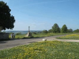
'Four Shires Stone' on the eastern outskirts of the town denotes the original meeting place of the counties of Gloucestershire, Oxfordshire,
Warwickshire and Worcestershire. There has been such a monument here since Saxon times, but recent rationalisation of county boundaries has robbed the site of its Worcestershire connection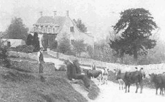 . .
Although that part of the Parish was administered with Hamptun Manor, it retained its identity, being henceforth referred to as the Tything of Rodborough. For the next 500
years Rodborough and the areas which now constitute modern Amberley Parish, were linked for local government under one officer known as a Tything man, with full
responsibility to uphold the law in the whole Tything. It is during this period that historical facts are extremely difficult to find, making the next stage of
the development of the Parish difficult to relate.
However, the fact that there are still various buildings and dwellings in the Parish from this period gives a firm impression of gradual habitation during
the period from the 14th to the 18th centuries. There are several examples of old weavers' and estate cottages of the later middle ages in Watledge,
Theescombe and St. Chloe and somewhat larger houses in Houndscroft, Pinfarthings and Theescombe, while beginnings of industry were emerging in
mills along the Nailsworth stream boundary in the Woodchester valley during the same period.
The western area of the Hamptun Parish was developed mainly in the later 18th and early 19th centuries when the building of cottages on the hillsides
at the edge of the Common greatly enlarged Box and produced another sizeable village at Littleworth and smaller settlements at St. Chloe,
Amberley, Theescombe and Pinfarthing. Most of the seventy or so cottages built on former Common land that paid rent to the Lord of the Manor in 1809 were in those places.
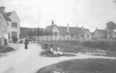
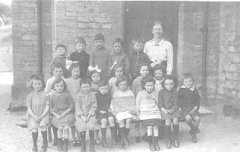
The building of the new Churches at Amberley in 1836 brought considerable change to the ecclesiastical part of the old Hamptun Parish. The end of an
incumbency saw the dismemberment of the benefice by the creation of new ecclesiastical districts, both for those Parishes and for the ancient Church at
Rodborough which had been served in later years by a priest who was regarded as a curate by the Hamptun Vicar. These changes, together with
the one at the end of the 19th century which saw Nailsworth created a Parish from parts of Hamptun, Avening and Horsley manors, created
different boundaries for the civil and ecclesiastical parts of the newly formed Parish of Amberley.
It seems surprising that when this newborn Parish was brought to its christening and someone said "Name this child" it was Amberley that
emerged, not Littleworth or either of the other settlements around it. Possibly the fact that the Methodist Church was known as Littleworth may
have been the determining factor because the only part which seems to have been previously known as Amberley was the area between Spriggs Well
and where the Amberley Inn now stands, and this was part of Amberley Coppice.
The only Amberley place name in a document written before 1066 is, strangely enough, The Drillies. The word can mean either a dry pasture or path and seems to be the name given to the area enclosed by the
earthworks on the Common between the Post Office and the Pines. This may have been a large stockade with a path leading out across what is now
the road in front of the school, and entering the dense woods which largely covered the hillside between Nailsworth and the space occupied by Amberley Churchyard today.
This document is a Charter connected with grants of Church land and is included in the records of the old Hamptun manor. It apparently states that,
in the reign of Alfred the Great, AD 871-901, there were disputes about the Parish boundaries of that time. Apparently, the boundary marks were to be
cleared of all undergrowth and the inhabitants were to walk from mark to mark until they knew their exact positions. The name Amberley does not
appear in these old documents or in the later manorial rolls but it seems almost certain that it existed, not as a village, but as a place where the people assembled to beat the bounds.
The growth of the area since the Churches were built can best be seen by studying maps and census records of the 19th and early 20th centuries. Old tithe maps of 1804 and 1839 give indications of some
30 to 40 and around 100 dwellings respectively, suggesting some 150 to 200 persons for the former, and around 500 for the latter. Census figures
for the middle of the 19th century show a dramatic rise to well over 300 dwellings and a population of around 1600. It is fair to point out that the
1804 map only included the area from Watledge to Lower Littleworth, while the 1839 figures included the whole of Houndscroft to the Bear Inn.
The population figures drop to some 1250 by the end of the century, probably because of the creation of Nailsworth Parish from parts of
Avening, Horsley and Hamptun manors in 1892. This figure appears to have been maintained throughout the 20th century up to the time of the second world war.
To close, it is worth looking at the ways of travelling from the Parish to other areas such as Minchinhampton, Nailsworth and the Nailsworth valleys
several centuries ago. A study of the large Ordnance Survey map for the area shows it criss-crossed with a large number of footpaths and tracks,
and it is obvious these were then the only way of getting in and out before the road system we have today was developed. Most of the paths and
tracks, which cross the Common to Minchinhampton, Burleigh and Box linked up with others which led through the various woods and fields to
points along the Nailsworth valley. Several of these are still usable today as long as one is dressed to suit, but many have become almost completely covered in undergrowth.
The map also clearly confirms the fact that the whole Parish area is riddled with underground streams which cascade into the valley stream at many
points. A walk along the old railway line from Nailsworth to Woodchester clearly demonstrates this, as there are a considerable number of piped
entries into the stream which runs alongside it. Another source of confirmation is the fact that many of the houses for sale during the period
from the 1850s until the 1930s were advertised as having their own spring water and/or well supply. Records indicate that before the present water
supplies became available, many of the houses had their own wells, most of which have now been filled in or built over.
This combination of underground streams and the soil structure has also resulted in several instances of landslip along the hillside during the 19th
century. Examples recorded are at Dyehouse when the railway was being built, when apparently one Mr. Tabram went to bed at night with a saw and
a hatchet so that he could open his bedroom door when it jammed in the night. There was also a stream below Amberley Court in Theescombe
which was only contained by a combination of drains and buttress walls and a further example resulted in the old house at the Highlands being pulled
down because it had become unsafe for habitation. It is certain, however, that without this natural water supply, our Amberley may never have existed, as it was a long way from the valley streams.
Finally, it is interesting to note the way that some of the Parish names have developed over the years. Originally, part of the old Hamptun Manor boundaries were marked by a path, and this was apparently
known as the Bagpath or Packpath. Along the line of this path were the holdings of lands held by various persons either by means of a rent payment
alone, by rent payments and specified services or by services only. Among these in the old Rodborough Tything were the ones at St. Loes, as
previously mentioned, Houndscroft and Watledge. Houndscroft apparently derived its name from the holding of one John Hund while the neighbouring
one, now occupied by Moor Court and the Bear Inn in particular, was at that time and for many years, the holding of the Horestone family, possibly
named from the very stone which marks the limit of the Rodborough and Amberley civil Parishes. Watledge bears one of those names which have
passed through many changes of fortune and seen better days. It seems to have begun as Heardanleah, a boundary post mentioned in Ethelbald's
Woodchester grant. This means the Warders clearing, or the Warders field, and approximately 500 years later had become Wadden. Later still it was
Wadden Edge. Then, in the early 19th century, it was Wadedge and later Watledge with the T creeping in during the last 100 years. On a tentative
map of the Hamptun Manor c. 1300, the area now known as Theescombe is referred to as Maelscombe, possibly after Roger Mael or Mayel, a 14th
century adventurer. It seems, however, that the modern name is probably derived from the words 'Thieves Combe' denoting a valley haunted by thieves. 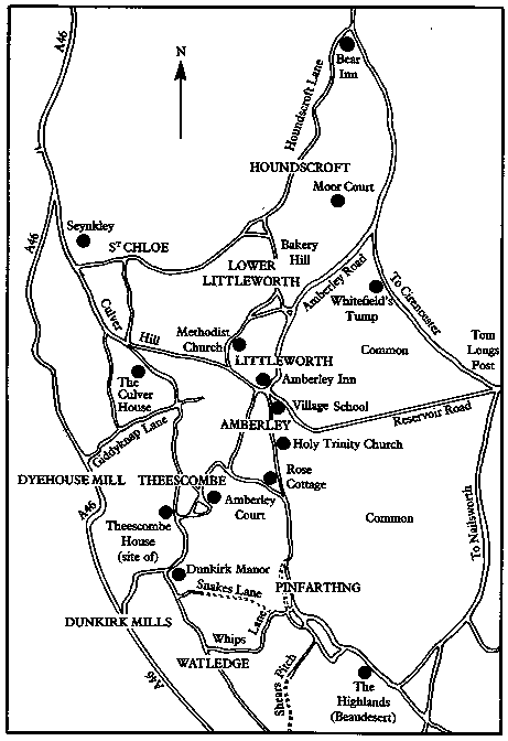
Pinfarthing, referred to during the 19th century without the 's' at the end, appears to have emerged from a combination of pen (as for enclosing property or stock) and farthing (a quarter).
Text, map and photos extracted by permission from "A Village of Parts" by Roy Close
ISBN 0 9511658 0 1
|