|
Wallingford was a walled Saxon Town on the Thames, and the remains of the town walls can still be seen today. William the Conqueror built
Wallingford Castle, which was used as a royal residence until the time of the
Black Death. The Castle was demolished by the order of Oliver Cromwell in 1646 after a 65 day siege. The 350th Anniversary of the siege is being
celebrated this year. The remains of the Castle can be seen from the Castle Gardens.
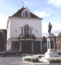
The Town Hall, built in 1670, houses the Town Plate and many portraits
including the only known portrait of Judge Blackstone. Other portraits painted by Hayller, Lawrence and Gainsborough may be viewed by appointment.
Wallingford was formerly a Borough, having its first Charter granted in 1155. The Council are still robed and the Mace is processed on Ceremonial
occasions.
Today Wallingford is a thriving Market Town; the centre is a major conservation area with examples of churches and architecture dating back to
the 14th Century. The landscape from the River Thames is officially designated as an Area of Outstanding Natural Beauty.
The narrow streets with their variety of small shops, pubs and restaurants, the antique shops in the Lamb Arcade, and the parks, commons and gardens
make it a very pleasant town.
Wallingford is within easy reach of both the M40 and the M4, and is only 15 miles from Oxford.
|